

- What is a primary source when doing research? What is a secondary source? Which one is better? When do you use these types of sources?
- What is a primary source for finding population data for Australia? Why?
- What is the population of Australia?
- What is the 'growth rate' of Australia for 2010?
- How many 'new' Australians were there in 2010?
- How many of the 'new' Australians were born in Australia and how many are immigrants?
- Which state had the greatest growth in population for 2010?
- What changes have you noticed in your area that could be related to growth in population?
- Is it good that Australia's population continues to grow?
- When, in history, has Australia NEEDED the population to grow? Why? Where did these people come from?
Subscribe To My Blog
Wednesday, June 15, 2011
Year 9 Geo Thur 16/6 + Fri 17/6: Changing Australian Communities
Tuesday, June 14, 2011
Communities + The best El Nino/La Nina Projects
Brainstorm about how your community has changed. This could be change in buildings, change in people, ect.
THEN....
You and your table members need to have a look at all the different projects posted in the comments section of the previous post (http://cavsgeographyclass.blogspot.com/2011/06/year-9-geo-el-ninola-nina-projects.html).
Choose one that you think is the best.
Then as a class we'll have a look and choose the best from the two classes.
Wednesday, June 8, 2011
Year 9 Geo El Nino/La Nina Projects
Please paste the URL of your group's work in the comments section.
after this please score your other group member/members for the following out of 5 (5 is the best):
1. Complete Work on Time
2. Communication
3. Quality of Work
Include a comment on your overall reaction to working with this person/ these people.
after this please score your other group member/members for the following out of 5 (5 is the best):
1. Complete Work on Time
2. Communication
3. Quality of Work
Include a comment on your overall reaction to working with this person/ these people.
Tuesday, May 31, 2011
Year 9: How many parts of the project have you complete?
In a short blog post, detail which of the six parts of the project you have completed, who did the work, and describe how far along you are on the parts not complete.
- World el Nino Map
- World la Nina Map
- Australia el Nino Map
- Australia la Nina Map (w/ natural disaster)
- el Nino Natural Disaster Fact Sheet
- la Nina Natural Disaster Fact Sheet
Then, GET TO WORK!!!
Monday, May 30, 2011
HTML Code to Publish a Google Doc in a Page
<iframe frameborder="0" src="(delete and insert your link)" style="height: 700px; width: 650px;"></iframe>
Wednesday, May 25, 2011
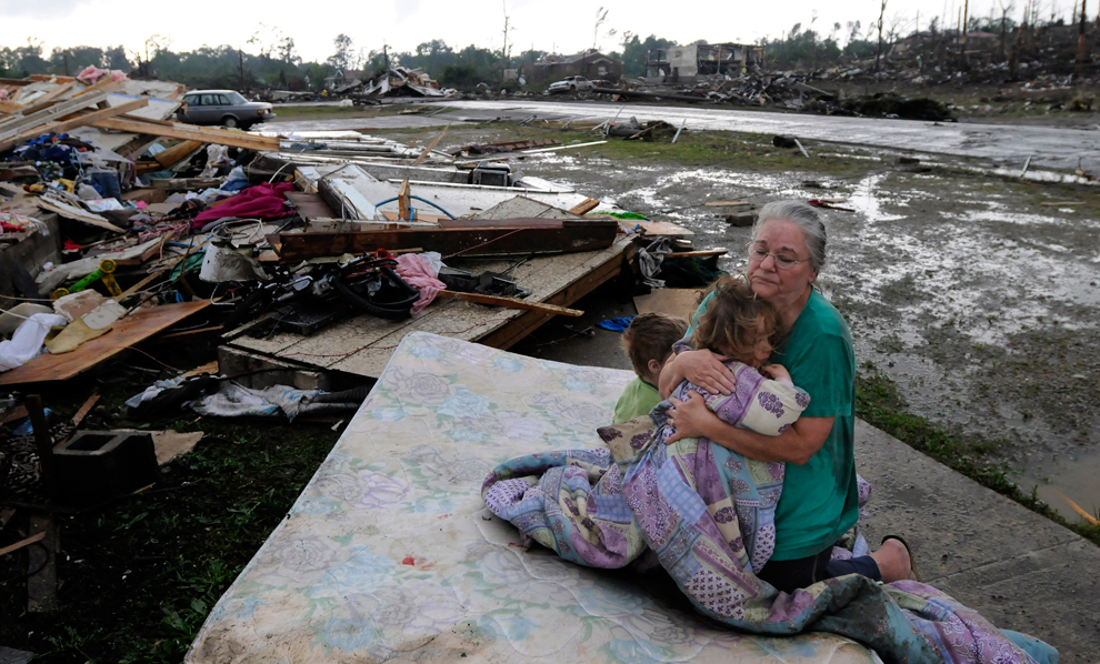
Severe weather continues in central US
Severe weather continues in central US: "


 "
"
Deadly storms struck again yesterday in the states of Arkansas, Oklahoma, and Kansas. It was a storm system that followed the massive, highest-rated EF5 twister that struck Joplin, Mo., on Sunday. The Joplin twister, which killed more than 120 people, is the eighth deadliest storm on record in the United States dating back to 1840. This year's tornado season has produced approximately 1,000 twisters and has taken the lives of more than 300 people. -- Lloyd Young
(36 photos total)
(36 photos total)
Debbie Surlin salvages items from her parent's home in Joplin, Mo. Wednesday, May 25, 2011. The home's residents Beverly and Roy Winans rode out the EF-5 tornado by hiding under a bed in the home. The tornado tore through much of the city Sunday, damaging a hospital and hundreds of homes and businesses and killing at least 123 people. (Charlie Riedel/Associated Press)
"
Year 10: Review of Task #1
The first task is done...So, how did it go?
I want you to take 5 minutes to write a post on your blog detailing about 'What went well' and 'What needs to improve.'
Also, looking at your graphs talk very generally about how Australia compares to the other countries you are comparing it to. Were there any surprises that you discovered about other countries?
Monday, May 23, 2011
The Worldwide 'Thirst' For Clean Drinking Water : NPR
The Worldwide 'Thirst' For Clean Drinking Water : NPR
Something for all you Geographers looking to do HSC Geo.
Sunday, May 22, 2011
Wednesday, May 18, 2011
Monday, May 16, 2011
Year 9: Tuesday 17/5 Exam Prep

1. How many hectopascal (hPa) is the high over the Eastern side of Australia?
2. What LARGE part of Australia is experiencing rain?
3. Give the approximate location of the centre of the high on the east coast?
4. How would you compare the speed of the wind for Australia to New Zealand?
 5. What month has the warmest temperature?
6. What hemisphere is this city in?
7. What month has the highest rainfall?
8. What is the average temperature and rainfall for November?
9. What latitude do you think this city is at? Why?
Wednesday, May 4, 2011
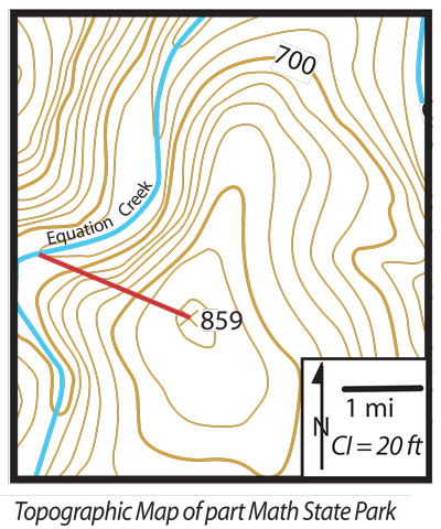
Year 10+ 9 Thursday 5/5: Mapping
Using the Synoptic Maps and the Sydney weather report below answer the following questions: (more questions under the synoptic charts). Copy the images from this page and put them in your blog.
- What is it about the pressure system stalled over Australia that relates to the weather over the next 4 days?
- What is the air pressure in each of the next 4 days for each of the capital cities? How does this correspond with the predicted weather for these cities?


- What is the contour interval (sometimes abbreviated CI)? Convert to metric.
- What is the scale of the map? Convert it into the metric system
- What is the gradient of the line? Calculate in metric system.
Tuesday, May 3, 2011
Monday, May 2, 2011
Deadly Storms in the US
Sunday, May 1, 2011
Monday 2/5: 2.2 Landslides, Earthquakes and Tsunamis + Consolidating Group Work
Today you need to bring all of the work you did individually in your group on natural hazards into one post. Each of you should have a post on your blog consolidating all the information you have gathered.
Also, you need to begin 2.2 questions 2.2 to be finished tomorrow in class.
Also, you need to begin 2.2 questions 2.2 to be finished tomorrow in class.
Thursday, April 28, 2011
Year 10: Monday 29/4 Work
I'm away today getting the final check up on my surgically repaired knee. So you guys have some School Certificate (especially mapping) work.
Do all the questions on the worksheets provided and the questions below. Post all your answers on your blog.
Do all the questions on the worksheets provided and the questions below. Post all your answers on your blog.
Monday 2/5
All work due next class.
Additional Questions for 2002 School Certificate
In addition to the questions that are included already complete the following questions regarding Source H on pg 22 and Source I on pg 24.
pg 22 Source H
What is the distance and local relief between the centre of the pine plantation and the factory?
Give the Grid Reference for the Coal Mines as well as the local relief and distance between them.
Give the Grid Reference for the intersection of the walking track and sealed road.
pg 24 Source I
What is the air pressure at Sydney and Perth?
What is the wind speed and direction at Rockhampton?
What is the Latitude and Longitude at Melbourne?
What is the Latitude and Longitude where it is raining?
What is located in the SW just off the map?
Year 9 Fri 29/4: 2.1 Review and Analysing Natural Hazards
1. Each of your groups is assigned a natural hazard. For your natural hazard list 5 unique concerns for the three types of impacts this hazard can have on communities. Then describe how the different groups in question 11 of 2.1 Questions would need to react to you particular hazard.
2. Review 2.1 Questions
2. Review 2.1 Questions
Wednesday, April 27, 2011
Year 10 Thursday 27/4 - Venice a City in Five Images
Today we are going to have some fun as we transition into our next unit. I have a video on 'how Venice works'. Venice is a city of immense historical importance and also one that is truly unique in how it works.
What are we doing?
1. Watch the film.
a. While we watch we are going to take notes and decide on 5 aspects of Venice which we think are most important to what makes the city unique.
2. For the remainder of the class and for homework over the weekend you are going to choose a city in the world (let me know before you leave class what you are planning on doing) and make a post on your blog with five images which captures what makes this city unique with an explanation for each image as to why you choose it.
Venice Backstage. How does Venice work? from Insula spa on Vimeo.
Friday, April 22, 2011
Year 9: Wed 27/4 - 2.1 Intro to Natural Hazards
You have 5 minutes to complete the crossword below (don't work with anyone else see how well you can do on your own).
Then you are going to work on the 2.1 questions 1-11 in class. If you don't finish they are homework.
Monday, March 28, 2011
Year 10: Tuesday 29/3 Final Prep for Tomorrow
Fingers crossed you did your work yesterday and have half you assessment ready to roll...
Today you need to take care of the second half:
1. Two Responses to Urban Sprawl and/or Urban Consolidation
2. Evaluate the effectiveness of one response: Choose either sprawl of consolidation and have your say whether you think it is effective or not.
Make sure you use the structure from yesterday for each paragraph:
1. Topic Sentence
2. Explain topic sentence.
3. Examples/Statistics
4. Explain relevance of Examples/Stats
5. What effect does this have on Sydney?
Subscribe to:
Posts (Atom)